


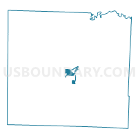
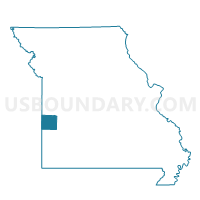
Home EC Building Voting District, Vernon County, Missouri
About
Outline

Summary
| Unique Area Identifier | 611507 |
| Name | Home EC Building Voting District |
| County | Vernon County |
| State | Missouri |
| Area (square miles) | 3.31 |
| Land Area (square miles) | 3.26 |
| Water Area (square miles) | 0.05 |
| % of Land Area | 98.61 |
| % of Water Area | 1.39 |
| Latitude of the Internal Point | 37.83453960 |
| Longtitude of the Internal Point | -94.33054000 |
Maps

Graphs
Select a template below for downloading or customizing gragh for Home EC Building Voting District, Vernon County, Missouri


Neighbors
Neighoring Voting District (by Name) Neighboring Voting District on the Map
- 1st Baptist Church Voting District, Vernon County, MO
- Courthouse Voting District, Vernon County, MO
- United Methodist Church Voting District, Vernon County, MO
- YMCA Voting District, Vernon County, MO
Top 10 Neighboring County Subdivision (by Population) Neighboring County Subdivision on the Map
Top 10 Neighboring Place (by Population) Neighboring Place on the Map
Top 10 Neighboring Unified School District (by Population) Neighboring Unified School District on the Map
Top 10 Neighboring State Legislative District Lower Chamber (by Population) Neighboring State Legislative District Lower Chamber on the Map
Top 10 Neighboring State Legislative District Upper Chamber (by Population) Neighboring State Legislative District Upper Chamber on the Map
Top 10 Neighboring 111th Congressional District (by Population) Neighboring 111th Congressional District on the Map
Top 10 Neighboring Census Tract (by Population) Neighboring Census Tract on the Map
- Census Tract 9503, Vernon County, MO (6,049)
- Census Tract 9501, Vernon County, MO (3,422)
- Census Tract 9504, Vernon County, MO (3,197)
- Census Tract 9505, Vernon County, MO (3,184)
- Census Tract 9502, Vernon County, MO (2,215)